|
TWINSAT
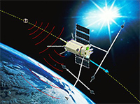
TwinSat is a UK-Russia project destined for the development and practical implementation of integrated aerospace and ground technologies for early detection and monitoring of large magnitude earthquake precursors and demonstration of the possibilities for their practical use to improve an accuracy and reliability of short-term forecasting of impending earthquakes. The research program includes the development, launching on orbit and 2 year operation of two experimental spacecraft, the micro satellite TwinSat-1M and the nano satellite TwinSat-1N, coordinated with accompanying ground-based observations on geophysical polygons in selected seismically active zones. The satellites and ground stations will observe a range of signals that have been shown to be related to earthquake precursors and search for new precursory signals. The innovation scheme, which foresees usage of two satellites with controlled separation and information exchange will allow obtaining the data on the spatial structure and the dynamic characteristics of studied phenomena and therefore significantly improved recognition and discrimination of earthquake precursor signals from other naturally occurring phenomena in the ionosphere. This R&D program concludes with the conceptual design and feasibility determination of a follow-on satellite constellation and issue of PDR for the System of Early Detection and Monitoring of Earthquake Precursors composed from space, aerial and ground segments.
|
|
Project Leaders: Dr. Vitaly Chmyrev and Prof. Alan Smith
Participating Institutions:
-- GEOSCAN Technologies
-- Mullard Space Science Laboratory, University College London, UK
-- Schmidt Institute of Physics of the Earth, Russian Academy of Sciences, Moscow, Russia
-- Institute for Risk and Disaster Reduction, University College London, UK
 Project profile
Project presentation
|
|
AVIS
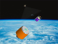
The project is aimed at the development and creation of autonomous video-information system on the basis of nanosatellite with 3-axis attitude control devices and tiny thruster, video cameras and two independent data transmission channels. The work program foresees the development and experimental verification of separation, approaching and docking technologies for nanosatellites of numerous applications. AVIS is a 2-stage space project. First stage includes the building and trials of a demonstration sample of pico satellite AVIS-1P dedicated for confirmation of functioning in the flight conditions, performing the video filming of the investigated objects and the transmission of obtained information on-line to ground control center via independent satellite communications channels. The demo AVIS-1P will have dimensions ~10x10x10cm and mass ~1kg. It is assumed that initial experimental verification of picosat will be carried out on the International Space Station, first in the docked state on the element of external construction of the Station and then in flight after the launch performed through the specialized starting container by cosmonaut when leaving for the work in open space. The 2nd Project stage work program foresees the development of AVIS-1ND nanosatellite with anticipated dimensions ~30x10x10cm and mass ~3kg correspondingly, equipped with 3-axis attitude control system and thruster. A couple of nano satellites in AVIS-1ND configuration will be built for experimental verification of the separation system on orbit, the reverse operation of rendezvous and docking with use of the docking device. This program is realized in cooperation with RSC ENERGIA under financial support of Skolkovo Foundation.
|
|
Project Manager: Dr. Vitaly M. Chmyrev
Participating Institutions:
-- GEOSCAN Technologies
-- S.P.Korolev Rocket & Space Corporation ENERGIA
-- Yu.A.Gagarin State Scientific Research-and-Testing Cosmonaut Training Center
-- Mission Control Center, Central Research Institute of Machine Building
|
|
MassMIMO Antenna Design Suite
&
ADAPTENNA
The telecom projects MassMIMO Antenna Design Suite, ADAPTENNA, and others are now spinning off into a separate company. Updated information and contacts will be placed here soon. For details, contact Igor Sergeev by  . .
Updated "Quick Overview and Application Examples" of MassMIMO Antenna Design Suite can be downloaded here.
|
|
HATP

HATP is a high altitude telecommunication platform. The core technology is M-55 stratospheric aircraft. Whether treated as a low altitude geostationary satellite or a tall mast, the M-55 holding a mobile base station and flying in a circular corridor at an altitude of 20 km creates a cone of high-speed wireless link over a service area between 200 and 500 km in diameter. M-55 is a piloted plane, capable of carrying up to 2000 kg of essential communications payload and power supply up to 40 kW. The network is provided at all times by a relay service operated by 5 aircrafts, each flight time lasting about 5 hours. Through the use of onboard smart antenna system, advanced propagation techniques and exploitation of the best aspects of satellite communications technology, GN is intended to make communication ubiquitous, instantaneous and unlimited in capacity. It can be described as the third form of wireless communications infrastructure after terrestrial and satellite networks to meet the communication needs of the 21st Century. GN is a multi-functional infrastructure that enables delivery of a wide range of multi-media services to fixed and mobile terminals. These services include voice, text, video, high speed Internet access, eEducation, eHealth, eBusiness, eGovernment, Electronic News Gathering, real-time information from financial markets and live transmission from sporting arenas and concerts.
|
|
Project Manager: Dr. Vitaly M. Chmyrev
Participating Institutions:
-- GEOSCAN Technologies
-- MYASISHCHEV Design Bureau, Zhukovsky, Moscow Region, Russia
-- QucomHAPS Holdings Ltd, Dublin, Republic of Ireland
-- Research & Production Enterprise POLYOT, Nizhni Novgorod, Russia
|
|
|
|
|